IT TRANSPORT - ROAD ASSET MANAGEMENT SYSTEM (ITTRAMS)
History of ITTRAMS
We (IT Transport Ltd) and our company directors have worked with, and been involved in the development of, road management systems since the 1980s when all the systems were paper-based.
One of the first countries to move to record its paper-based system onto available software was Kenya with its RMS (Road Management system) and PMS (pavement management system) databases in the late ‘80s. The system was still paper-based but the data collected on paper was physically transmitted to the central Roads authority (Ministry of Public Works) where it was manually entered into a FoxBASE database that could be queried using the FoxBASE tools. Our principal directors at the time were closely involved with this through their involvement with the management and support to the Minor Roads Programme of Kenya.
More....
Things developed quickly from there and we were involved in several attempts to take the next step to bring data entry down to the regional and district levels in Ghana, Kenya, Lesotho and Mozambique. This proved difficult at the time as the technology and people’s familiarity with it were disparate. Hardware was not always available and electrical power to many districts and regions was fraught. This meant that the software systems remained mainly a centralised Headquarter (HQ) activity and regional data was still paper-based.
Together with many other players both in the private and public sectors, we continued our efforts to automate the data collection, planning and recording processes through the 1990s. It was clear that one major factor at the core of any road management system had to be the Road (Asset) inventory. With the paper-based systems, data would often come from the regions for roads that were not easily identifiable on the paper map and not in the paper-based list of roads. It became clear that the same road was identified in different ways by different authorities and different agents.
A big step forward in the development of RAMS came from our work in Ghana in the early noughties using GIS to fully map the regional road network to allow paper-based plans to be coordinated with digital maps. This culminated in a planning system based on the GIS inventory, traffic levels and road conditions to give a level of intervention and maintenance budget. A simple spreadsheet-based system, similar to HDM4 and RED of the World Bank but much simpler in operation and concept. Our software developers worked at the same time with other agencies and companies in Zambia (STROMAS), Tanzania (DROMAS) and Ethiopia to develop similar systems.
In the second half of the noughties, we managed to develop a rudimentary system that could enter inventory data, enter a district maintenance plan and track and report maintenance contracts and force account work and link all this to GIS based road network. This was the first version of RMMS in Kenya that electronically linked district plans to HQ management systems. It was developed in cooperation with the district engineers in Nyanza province and was more easily adopted for general use. It was disseminated by the Kenya Roads Board (KRB) for use throughout the network and other road authorities and allowed them to receive data electronically for use in the HQ-based RMS that was already in place.
It was after this success in Kenya that we went on to develop an updated version of the DROMAS system (DROMAS 2) for Tanzania. Knowing the pitfalls and problems that have to be faced and the length of time it takes to have such a system disseminated and used, we were able to establish DROMAS 2 for the use of planning, contract tracking and reporting and linking to financial allocations so that both physical and financial progress can be tracked and reported accurately.
We have now further developed an in-house piece of software (ITTRAMS) for road authorities that can be used at all levels and can be customised to suit the client’s options and intentions. Different modules, which can be tailored to client’s needs, of ITTRAMS are described below.
Introduction
ITTRAMS is an enterprise cloud-based asset management solution that enables a road authority to link strategic objectives to its planning, maintenance operations and investment decision making
Core Features:
- Inventory development
- Condition monitoring
- Automated strategic and detailed planning.
- Contract management and payment control
- Financial monitoring and reporting
Modules:
- Map
- Road Network
- Planning
- Contract Management
- Finance
- Reporting
More on the modules and features
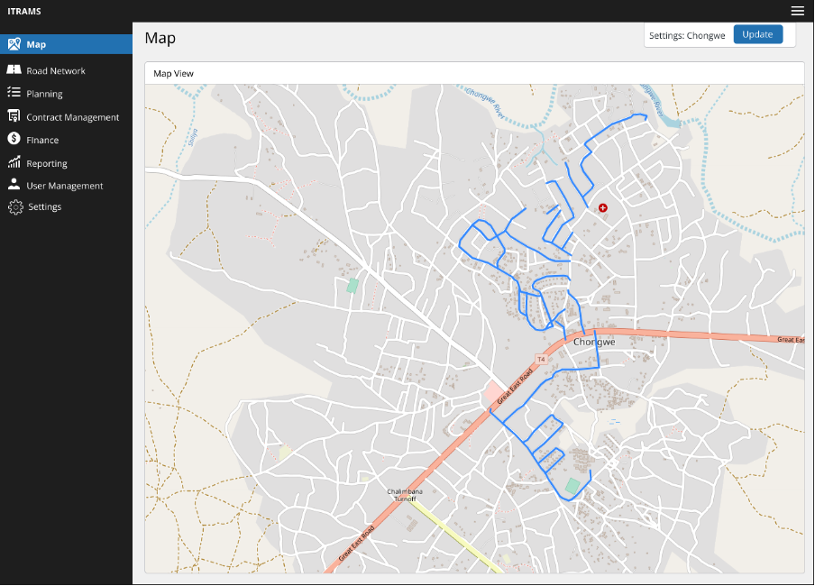
Mapping
Visually display the road network and easily identify issues with colour-coded lines
Road Network
An Inventory and condition database containing as much data as you need. This includes collecting data on road furniture and any related information.

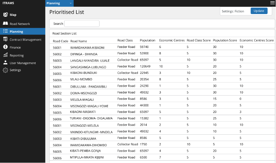
Planning
An automated planning with functionality to link to financial allocations. The module allows you to automatically prioritise work based on various scores and formulas decided by you.
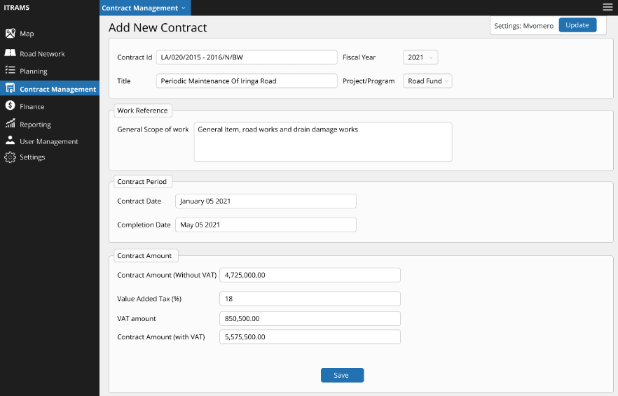
Contract Management/Finance
The contract management module can be used to track contracts attached to the planned works. This can then be used to track progress as well as manage costs and budgets.
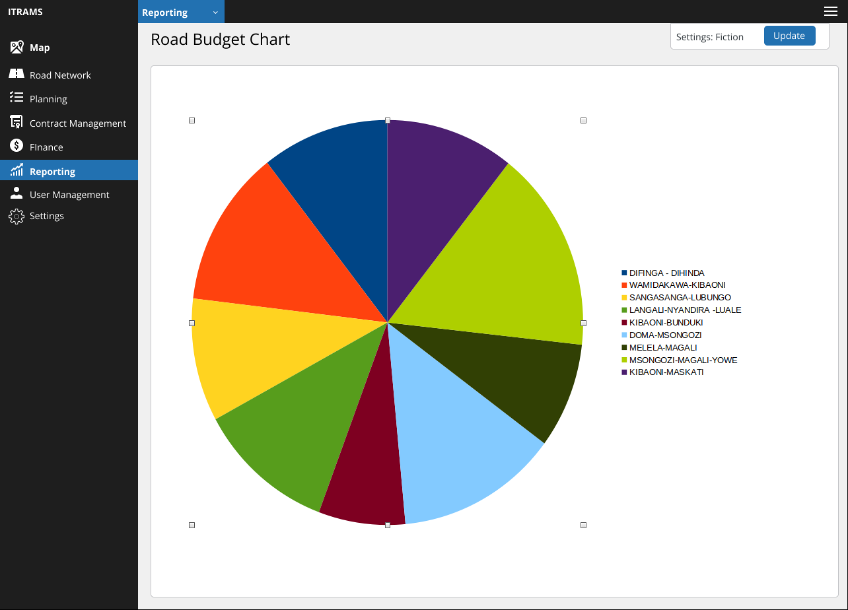
Reporting
The reporting model enables you to create your own reports based on the data fields you have set up. The reports can be visualised into graphs and charts for better presentation
User Management
The system gives the ability to give access to multiple users with different access rights to data based on the roles within your organisation.
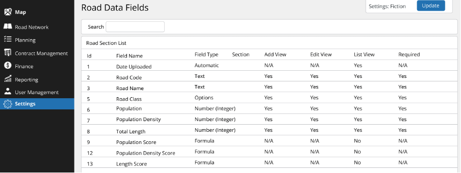
Fully Customisable Fields
The system allows you to customise nearly all the data fields. This includes the road network, contracts and contractors and the planning criteria. This allows you to have a system that is suited to the organisation and how it works.
Fast and Secure
ITT-RAMS is built on a modern cloud-compatible infrastructure. All communication is encrypted. Passwords are stored using a one-way secure hash and other sensitive data can be encrypted if required.
